Trying out new ways to document safety issues on streets
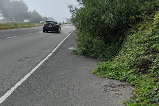
One recent Saturday I took a casual ride via the Skyline route from SF to San Mateo. This is a route I often take during non-shelter-in-place times to make the "long commute" from Sausalito to Mountain View with SF2G . I used the opportunity to photo document some bicycle safety issues on the route (mostly debris and overgrown vegetation into the shoulder). I used rough guide: cataloging issues where more than 1/2 the shoulder is unavailable for some reason. Yikes! Overgrown vegetation + glass + high speed traffic Caltrans has jurisdiction for the roads where I was cataloging issues. I know that they have an online submission form , but I have come across a few issues with this approach: You have input a specific geolocation for each issues, and I had over 20 issues to report There is no embedded w...